Sunday, January 16, 2022

North Wales Pilgrims' Way - Stage 5 (Eglwysbach to Llanfairfechan)

I'm waiting!

So the forecast was for a dry bright morning. As we drove along the A55 the rain intensified, our windscreen wipers flashing across the window at top speed. We revised the day's plan, from Eglwysbach I would run as far as Rowen and have a rain check there! At least we would have crossed the Afon Conwy which would feel like a significant achievement. Skip didn't seem worried one way or the other as we set off down a watery track spotting a large piece of slate perched on some rocks with an interesting handrail. What could this have been? A bus stop? On our return to Eglwysbach sometime this summer - to go and have a pint in the Bee Inn of course - we must ask if any of the locals know what this was for. We slogged onwards towards Rowen, the rain showing no sign of abating.


But there's no one here!
The sky seemed a little less grey by now and descending into Rowen village things looked slightly more positive. At the rendezvous with our wonderful driver Vicky, we decided to press on. Of course half a mile out of the village the heavens reopened, there was nothing to it but to crack on upwards onto the hills. At the top of a particularly steep climb (about 200m in 1.5K) we came across the remarkable ancient church of St Celynnin. Apart from one property a few hundred yards away there's not much else around here as far as human habitation goes so there's no regular worship taking place. However the church is still in use, what's more a female priest was ordained here fairly recently by the Bishop of Bangor. Apparently Bangor Cathedral was unavailable due to COVID restrictions so Bishop and novitiate together with one or two guests hiked up the mountain to perform the relevant ceremony. I nipped inside to say a prayer and sign the visitor book on behalf of Skip and myself and returned outside to find that the rain had disappeared!

Wind and rain outside - peace and quiet inside.

Where are they all going?
We started to make good headway across the tops, I knew some of these tracks from the various fell races that take place over these hills. The Tal y Fan race from Rowen and the Penmaenmawr Fell Race in particular are known for runners misdirecting themselves, in the low mists that are common up here it's easy to go wrong and I have been slightly guilty of this myself in the past. With map and compass at the ready I was well prepared - but the air was clear, the sky was blue by now and we found our way. The photo is evidence of the criss crossing pathways up here, several of which converge near the Penmaenmawr Stone Circle one of many prehistoric ceremonial and burial sites which litter the hillside. (Why did so many folk live up here at that time? Perhaps it was warmer back then!) So on this way-marker post we can see advertised the North Wales Pilgrims' Way, the North Wales Way, a Conwy Trail and the Wales Coastal Path, although we are well away from the coast right here. I won't ask any more questions.

Our day's ramble finished with a steep descent to the Nant y Coed Nature Reserve at Llanfairfechan. Closed at the moment due to fallen trees blocking access it nevertheless looks a pretty spot and has been appreciated by visitors for over a century with its waterfalls and stepping stones and varied wildlife. It's known in particular for its population of sessile oak trees. This are just like regular oaks but the acorns are not on stalks, rather they are attached directly to twigs - this picture shows how it's done (it's not my photo, wrong time of year!) At the entrance to the nature reserve was an informative signboard in Welsh and English, I was puzzled however by the comment that overhead "you may hear the mewing of the vulture-like buzzard"! I suppose that this means that most of today's visitors are more familiar with vultures rather than buzzards - too much TV perhaps?


Monday, January 10, 2022

North Wales Pilgrims' Way - Stage 4 (Gwytherin to Eglwysbach)

Been stuck here for days - help!
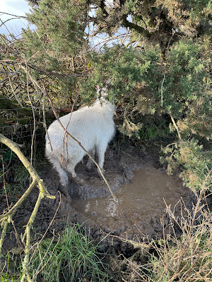
A brighter morning to start with and we had a pleasant climb out of Gwytherin up a lovely path in a wooded valley, all good so far. Skip and I encountered a couple of fallen trees which we spent a bit of time skirting round. Then, as we crested the top of the hill the heavens opened - we got wet....and muddy. Tramping over a moorland plateau I realised I'd been wise to pack dry socks. A quick downhill and a short road section saw us onto some very wet fields. I keep Skip on the lead when there are sheep around but let him off otherwise - and there we were, in a flourishing green field with no sign of grazing animals, I spotted movement in a hedge. A young but large lamb was standing in a big muddy puddle with its head stuck in fencewire; its backwards facing horns were preventing any escape. I extricated it with some difficulty and it bleated at me with gratitude, its backs legs sank to the ground and it started munching on a big tuft of grass. Clearly it had been there for some time - we were nowhere near a farmhouse so I had to leave it to fend for itself. Having kept sheep in the past I was confident that it would recover and retain a memory of that gallant pilgrim who had saved its life.

Pandy Tudur - anyone here called Andy?
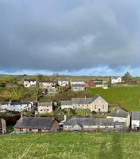
We headed onwards through a small village going by the name of Pandy Tudur, the word Pandy referring to the fact that there was a pre industrial woollen mill here. At this point the rain stopped and the village was bathed in sunlight. The largest building seen here is the Bethania Calvinist Methodist Chapel. Unlike Amglican and Catholic churches, which are generally named after saints, Methodist chapels are named after biblical locations and Bethania or Bethany is just a couple of miles outside Jerusalem - it's where Jesus raised Lazarus from the dead. Out of Pandy Tudur we climbed along past a farm on the outskirts of the village and were serenaded by half a dozen collies who raced backwards and forwards on the other side of a fence clearly trying get a rise out of Skip, but to no avail, Skip ignored them and we carried on up and over the hill.

Anyone at home?
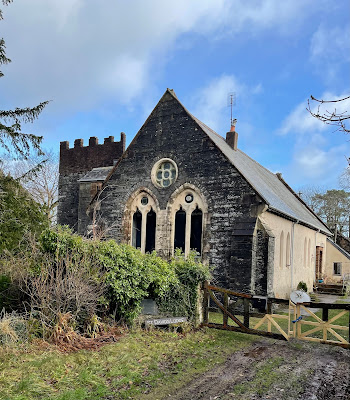
I had seen that the map indicated an old vicarage was coming up on our right. So by a vicarage you'd expect a church and indeed here is a church,  but it's a church no longer. I've been unable to find out much about it apart from the fact that it was built in 1867, which leads me to wonder who built it and who were the congregation, seeing as this was sited well away from the village. By the front gate is a wooden sign with St David's Lodge written on it so presumably that was to whom the church was dedicated. Next door is a large ruined vicarage which functioned as a nursing home until 2019 when it burnt down. The local fire brigade did well to get all the residents out without any major casualties!

Bring me chainsaw next time!
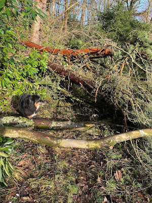
We'd been making fair progress at this point but our hopes of keeping going at a fair lick were dashed as we negotiated a woodland riverside path by the grounds of Hafodunos Hall. The hall, one of the most majestic residential buildings in Wales, was burnt down in 2004 but is currently being rebuilt; we'll have to go and take a look when it's completed. We trotted along comfortably on a well defined path, turned a corner and came face to face with this - a mass of trees had fallen directly across our way. We tried going up and round with no success, Skip getting snarled up in the tangled undergrowth. Eventually we backtracked to a fordable crossing point through the river and made our way round. This whole episode had cost us nearly half an hour.

Back on the trail we picked up our heels and to help us on our way we were pointed in the right direction by a kindly old woodman:

It's this way buddy!

Gurgle!

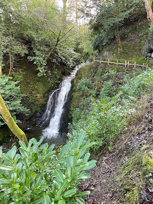
Heading into Llangernew we tracked the river further downhill and were rewarded with a pleasant amble through mature woodland spotting a gushing waterfall to our right. We passed the old hall gatehouse and trotted down the road. I had already realised that there was a lot to see in Llangernw, including the North Wales Pilgrims' Way Hub, and St Digian's Church with a 4000 year old yew tree in its graveyard. With little time to spare I decided to consign all this to a future visit and we stuck to the Pilgrims' route and galloped up the hill just before the village. At the top of a short climb a big metal gate barred the way forward. It wasn't padlocked but it might as well have been. A tightly knotted rope secured gate to post and no amount of teasing could unravel the contorted tangle. So for maybe the fourth time today I lifted Skip up and heaved him over.
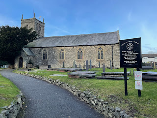
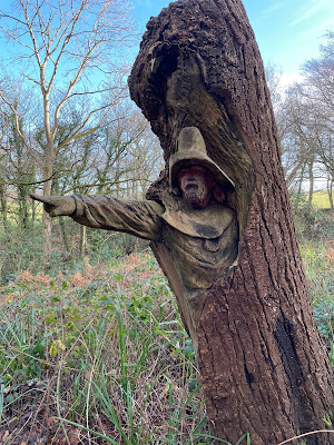
St Martin was here!
From the final peaks of the day we could see Snowdonia in the distant west, on a clearer day this would have been a magnificent sight as we descended down the steep tracks and roads into Eglwysbach. We passed Coed Annie (no idea who Annie is or was) and along the Afon Hiraethlyn onto our final rendezvous outside the Bee Inn, a fine looking pub. It's now the only pub in town but a hundred years ago there were plenty - in 1909 there was an objection to the renewal of the licence for the Bodnod Arms next door on the grounds that there was currently one pub for every 185 inhabitants, the pub failed to have its licence renewed but it then became the Aberconway Institute for use by the community, courtesy of the owner Lady Aberconway. I finished the day outside St Martin's church close to the Bee Inn. No dogs allowed inside the pub though - maybe we can come back in summer and have a pint in the beer garden, the beer should be good - each week the locals select a guest ale of their own choosing to sit on the bar next to the Bee Inn Bitter.


Thursday, January 6, 2022

North Wales Pilgrims' Way - Stage 3 (St Asaph to Eglwysbach)

The cathedral on a somewhat sunnier day
As I've mentioned before the cathedral in St Asaph was founded by the scottish saint Kentigern (who is also known as St Mungo, the founder of Glasgow Cathedral). The Welsh name for St Asaph is Llanelwy which means 'the church on the River Elwy'. St Asaph only appeared on the scene when St Kentigern/Mungo returned to Scotland and he appointed one of his disciples, Asaph, as Bishop of the cathedral. So just to complicate matters there is another church a couple of hundred yards down the road called St Asaph and St Kentigern, this is the local parish church and dates from the 13th century. And to round things off nicely the Catholic church in St Asaph is dedicated to St Winefride (who else!) You may think that I'm harking on a bit about all these saints but then this is a pilgrimage. 

There's a church on a hill
Our saintly visit to a very small city was over and we set off on the back road to Cefn Meiradog 5 miles away and the interesting looking St Mary's Church in a prominent position overlooking the tiny hamlet. I thought that it looked a bit grand for such a small location so I wasn't surprised when I found that, despite it's apparent antiquity, the church was built in the late 19th century to an Early English design funded by a local benefactor. Perhaps coonected to this is the fact that there is a St Mary's Well and ruined chapel down by the river that was a popular place of pilgrimage centuries ago. Sadly the well and chapel ruins are overgrown, the site doesn't appear to be visited any more and it's on private land - so we didn't go there!! 

Nice bit of wrought iron!
We crossed the old bridge at Bont Newydd (which is Welsh for 'new bridge' of course) and set off onwards and upwards on the other side of the valley clambering over fallen trees which following the recent storms were blocking the footpath - slow progress we were making! And it was beginning to occur to me that those helpful Pilgrims Way roundels on signposts and gates seemed to be far and few between today.  We managed to find our way over an undulating landscape of fields, some full of sheep some not, but all quite muddy until eventually we dropped down to the vale of the Afon Aled and a pretty little bridge in the hamlet of Bryn Rhyd Yr Arian. We were then able to make up a bit of time along a deserted track alongside the river - steady running all the way to Llansannan.


She's a mystery girl!

Here's a photo of the Little Girl memorial in the centre of Llansannan. Above her is a list of some of the famous townspeople including William Rees, a renowned Calvinist minister who was invited to travel internationally to deliver his sermons - sounds like a forthright character! The identity of the girl is a mystery, was she related to the chap who commissioned the sculpture, or the artist himself Sir William Goscombe John; or maybe she was a local girl, nobody seems to know. Goscombe John was a prolific Welsh sculptor whose works are more likely to be found in place like Cathays Park Cardiff

The name Llansannan derives from the church of St Sannan, another foreign bishop who roamed Wales in the medieval era leaving his mark here in the 6th century. Not much known about him but he was apparently a buddy of St David, patron saint of Wales, and also has churches named for him in Anglesey and South Wales. (In researching for and writing this blog I learn something new every day. Maybe this is widely known but I was unaware until today that the sailor's term Davy Jones's Locker is a reference to St David. Although I did, as a student, have an after hours drink or two - i.e. a 'lock-in' at the Davy Jones' Locker pub in Morecambe!) Rather than posting a picture of St Sannan's (I forgot to take a shot of it) I thought I should spread the good news around and give the fine Capel Coffa Henry Rees a mention for the non-conformists, of which there are many in Wales. From Llansannan we had a choice of routes and we took the road to Gwytherin as we were in danger of being seriously late for our rendezvous. 

I've been a bit top heavy with this leg regarding saints and churches and here's the final church at Gwytherin; surprise surprise it's called St Winifred's (note the slight change in spelling) but it's the same person who gave her name to the well in Holywell which we encountered on the first day of our meanderings. This building is no longer in use as a church but it's well looked after for posterity by a local group called the Gwenfrewi Project. The church was built in the 7th century on what is considered to be an ancient burial mound, the impressive yew trees in the graveyard are dated as being over 2000 years old and ceremonies may have taken place here as long ago as the Bronze Age

There was I waiting at the church!
Most medieval churches are sited on a west-east axis, generally the congregation will face the altar at the east end of the building. Is this because the second coming of Jesus Christ will be from the east, or was an earlier tradition of worshipping the rising sun a factor? Maybe it's a bit of both! And of the churches we've encountered thus far they all seem to be roughly facing east. Maybe they used a compass here in Gwytherin during the church's construction because it's not far off being exactly east facing - but then compasses weren't invented until the 11th century.  Do we have all the answers? No we don't! 

Saturday, January 1, 2022

North Wales Pilgrims' Way - Stage 2 (Trelawnyd to St Asaph)

Here goes again.
Started at Trelawnyd where we'd left off from the first leg - me and Skip making our pilgrimage across North Wales! Vicky dropped us off at Trelawnyd and the plan was to go as far as we could without flogging it too hard - we need to live to fight another day. Not the mist that we'd seen a couple of days previously and the rain was holding off so we set off in good spirits, charging over the first few fields albeit it was a bit heavy underfoot. Then the going got heavier, and heavier. Many of these fields were yet to be ploughed so I did my best to guide us down between the  cut down stalks of maize without tripping over them.


Why have we stopped?
A welcome break arrived at the Flash, this was a small patch of woodland that was very well maintained, in fact a number of trees that had recently fallen across the path had been cleared up quite nicely allowing me and Skip to make up time - apart from the time spent taking photos. This was soon over unfortunately and we were back in the mud. The OS map that we were trying to follow shows clearly designated paths across the agricultural landscape. The problem is that so often these paths don't appear to be there, a signpost will point across a ploughed field with no indication that anyone's been walking across it in the last few days so you have to take a compass bearing or an educated guess. What makes things worse is the fact that often stiles, etc, are poorly maintained and I frequently have to lift Skip over a padlocked gate on a public right of way.

On the other hand some landowners are doing the right thing and, once over the A55 near Rhuallt, we came across an airfield. We might not have known that it was an airfield but for the informative sign on this rerouted footpath on the other side of a properly signed sturdy stile. It was basically a large, not altogether flat field with no sign of any planes, no fuel depots, not even a wind sock! A large shed, perhaps housing a small plane stood in the corner next to a fairly grand farmhouse. Oh and there was also a large green dinosaur in the distance (it's there in the photo). The footpath took us around two sides of the airfield and down a grand driveway to exit through a small pedestrian gate within a much larger wrought iron affair.
We were on the road for a short while and glad of the opportunity to stretch legs out and make up a bit of lost time. Just before we left the road and reverted to footpaths we spotted some giraffes looking over a tall hedge - just what you'd expect near the top of the northern Clwydian Hills. Another fairly grand farmhouse, this was surrounded by big laurel hedges and, inside the perimeter, were an assortment of life-size figures of various animals, creatures from outer space (e.g. Darth Vader) and Michelle and Barack Obama! 

Moving on from the bizarre to something more normal for this part of the world, we reached the top of Moel Maenefa, at almost 300m high. This provided us with glorious views of the Vale of Clwyd and the North Wales coast over towards the Great Orme - magnificent! A lovely steep descent through bracken and gorse brought us onto  more frequented tracks and we saw four walkers, the first people we'd seen since we'd left an hour earlier. The pilgrims' route then took us south to the village of Tremeirchion. Our trail led to the back garden of the Salusbury Arms, a fine pub now owned by a microbrewery who sell their own Dove ales, yummy! The pub itself is one of the oldest in Wales and parts of it are at least 800 years old, furthermore it's haunted. An exorcism a few years ago succeeded in getting rid of four ghosts but it seems that three remain!

Which do we go in first, the church or the pub?
Next door to the pub is an even older church dedicated to Corpus Christi, a common enough label in the Catholic church, but this is the only non-Catholic church or chapel with this name. We missed out on calling in to St Beuno's college a couple of miles away - that's a visit for another day - but St Beuno's Well is also in Tremeirchion. Beuno was a Welsh saint who was uncle to our friend St Winifride and we'll hear more about the pair of them as the pilgrimage goes on. Apart from the antiquity of Tremeirchion the other thing that we'll firmly remember about the area is the mud, virtually all of the remaining section of the route to St Asaph was a slog through thick glutinous mud. It might have been appropriate to show a dramatic picture of my muddy legs and shoes but instead here's a picture of a wet dog in front of the cathedral at St Asaph.